Yosemite National Park

For a first visit to Yosemite National Park in California, start with Yosemite Valley for granite cliffs, waterfalls and short walks. Then choose giant sequoias at Mariposa Grove, the Glacier Point overlook or the Tioga high country around your interests and seasonal road access. Use the map and monthly comparisons below to build a realistic trip.

National Sites Guide

Share this page

Cite this page

Copy a citation

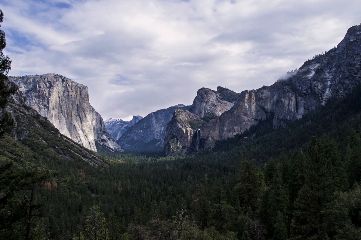
El Capitan rises on the left above Yosemite Valley, with Bridalveil Fall on the right and Half Dome in the distance.
Yosemite Valley from Tunnel ViewNPS / Cindy Jacoby
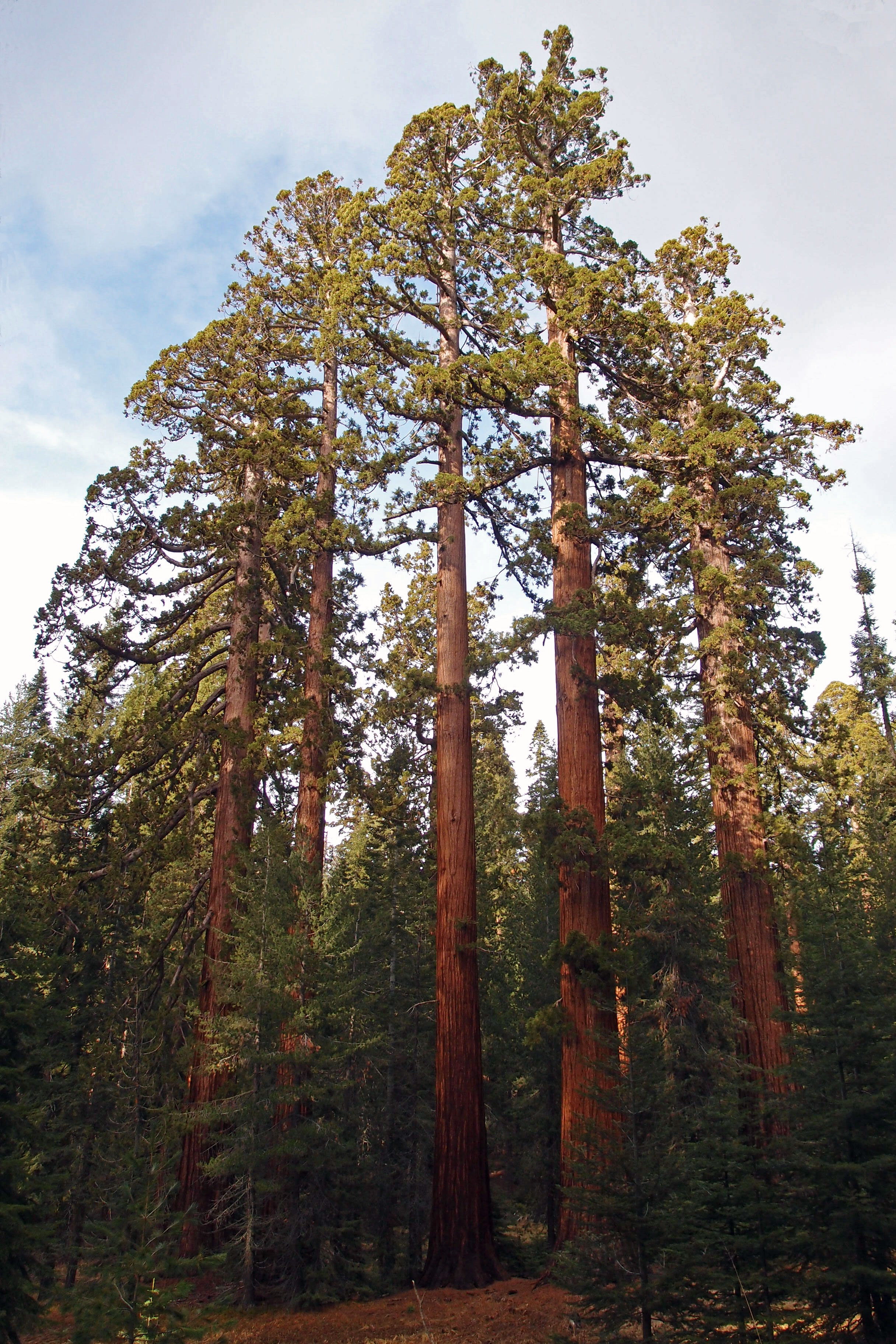
Several tall giant sequoias rise through evergreen forest beneath a cloudy sky.
Giant sequoias in Mariposa GroveNPS / Cindy Jacoby
Blue Tenaya Lake bordered by forest and granite slopes, with a boulder on the rocky shore in the foreground.
Tenaya LakeNPS Publications

Check before you go

Yosemite month by month

Open a monthly guide, then compare the park-wide visit pattern and Valley climate normals below.

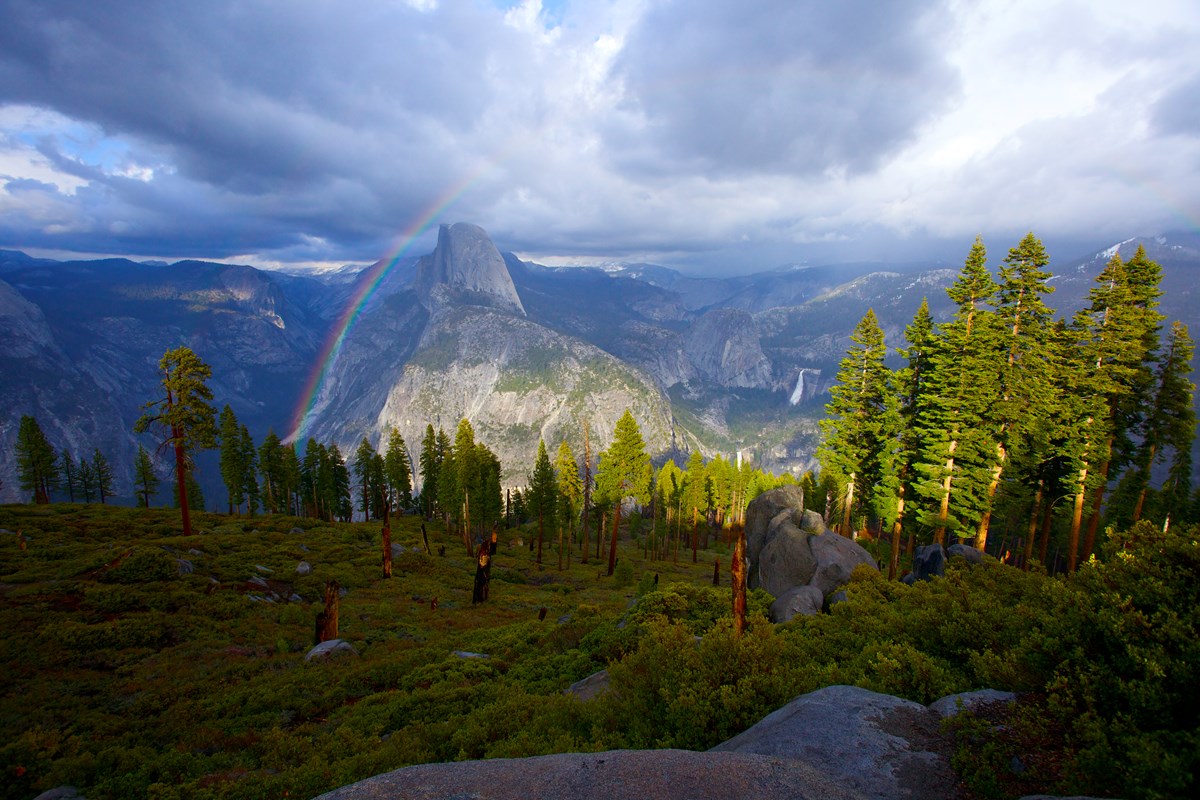
A rainbow over a mountain in the distance.
Rainbow over Half DomeNPS / Bob Roney

Best time to visit Yosemite

May through October

September is our pick because the normal seasonal trip remains practical and average visits are 12% less than the peak in August. Waterfalls can be much smaller by September, and high-country roads depend on snowfall.
Get to know Yosemite's main areas

Yosemite is in the Sierra Nevada of California. Its Valley, giant-sequoia groves, high overlooks and alpine country are separate destinations. Start with one area, then add what fits your season.

Yosemite roads and entrances Road locations, not live closures or exact gate positions. Wawona Road (Highway 41) El Portal Road (Highway 140) Big Oak Flat Road (Highway 120 west) Hetch Hetchy Road Glacier Point Road Tioga Road Glacier Point Road to Badger Pass (winter) Mariposa Grove Road O'Shaughnessy Dam Tioga Pass Entrance Big Oak Flat Entrance Crane Flat Yosemite Village Glacier Point Arch Rock Entrance Badger Pass Ski Area South EntranceN
Road locations, not live access or exact closure gates. © OpenStreetMap contributors; NPS park boundary and place data; U.S. Census state outline.
  • Wawona Road (Highway 41)
  • El Portal Road (Highway 140)
  • Big Oak Flat Road (Highway 120 west)
  • Hetch Hetchy Road
  • Glacier Point Road
  • Tioga Road
  • Glacier Point Road to Badger Pass (winter)
  • Mariposa Grove Road
  • Named viewpoints, trailheads and road junctions
  • Park entrances
  • National park boundary
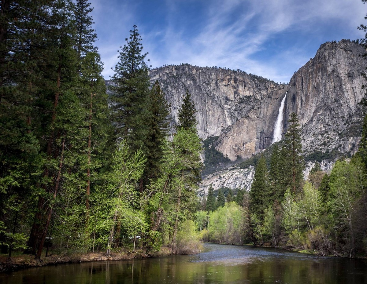
Waterfall descends a granite cliff above spring trees and the Merced River.
Upper Yosemite Fall and Merced River in springNPS Photo

Yosemite Valley

Start with a viewpoint such as Tunnel View, then choose Lower Yosemite Fall or Cook's Meadow for a walk. NPS recommends leaving your car parked while you explore the Valley rather than driving between every stop.

On the map: Yosemite Village is an area reference, not a waterfall trailhead. The photo shows Upper Yosemite Fall and the river; it does not show the Lower Fall approach.

The broad scarred base of the Grizzly Giant sequoia fills the image, with fallen logs in the foreground.
Base of the Grizzly Giant, Mariposa Grove, 2020NPS Photo / Ted Barone 2020

Wawona and Mariposa Grove

Choose southern Yosemite for giant sequoias at Mariposa Grove or the Yosemite History Center at Wawona. These are separate stops. The pictured Grizzly Giant is on a longer walk than the short Big Trees Loop.

On the map: South Entrance marks the southern approach, not the tree. Grove shuttle and road access are seasonal; without the shuttle, the approach adds walking before any grove trail.

Two visitors at the left look toward Half Dome from Glacier Point.
Half Dome from Glacier Point, 2020NPS Photo / Ted Barone 2020

Glacier Point

Choose this overlook for a high view across Yosemite Valley toward Half Dome. A short paved approach connects the parking area to the viewpoint when vehicle access is feasible.

On the map: Glacier Point is a scenic reference. Its road normally opens in late spring and closes in autumn, with snow deciding the dates. A winter ski approach is a different outing from driving to the overlook.

A seated visitor on Lembert Dome overlooks Tuolumne Meadows and the Cathedral Range.
Tuolumne Meadows from Lembert DomeNPS Photo / Ted Barone 2021

Tioga Road and Tuolumne Meadows

Choose the high-country corridor for lakes, meadows and granite domes. Give it its own place in your plan rather than treating it as another Valley stop. The photo looks across Tuolumne Meadows from Lembert Dome.

On the map: Crane Flat and Tioga Pass mark the corridor. They are not pins at Tenaya Lake or Tuolumne Meadows. Tioga Road normally opens in late May or June and closes for winter. Road opening and the availability of food, water and other services are separate checks.

Hetch Hetchy

Consider this northwest area as a separate reservoir-and-hiking outing. Its access road begins outside the main park road network near Big Oak Flat Entrance; Hetch Hetchy is not a stop on the Tioga crossing.

On the map: O'Shaughnessy Dam is an orientation reference, not a verified driving arrival. Check daylight road hours and winter access; summer hiking can be hot.

Yosemite crowds by month

These are five-year monthly averages of park-wide NPS recreation visits. They compare seasonal demand, not unique visitors, trail congestion, entrance queues or the chance of finding a parking space.

LowestLowModerateHighPeakAverage month: 320,874

Yosemite weather by month

Compare typical daily highs, lows and total monthly precipitation. These NOAA normals describe Yosemite Valley, not the colder, snowier high country, and are not a forecast for your trip.

Cooler Hotter
Jan
High48°F9°C
Low29°F-2°C
Precip · in6.98
Feb
High51°F11°C
Low30°F-1°C
Precip · in6.49
Mar
High57°F14°C
Low34°F1°C
Precip · in5.47
Apr
High63°F17°C
Low38°F3°C
Precip · in3.17
May
High71°F21°C
Low45°F7°C
Precip · in1.92
Jun
High81°F27°C
Low51°F11°C
Precip · in0.46
Jul
High89°F32°C
Low57°F14°C
Precip · in0.29
Aug
High89°F32°C
Low57°F14°C
Precip · in0.16
Sep
High83°F28°C
Low51°F11°C
Precip · in0.40
Oct
High71°F22°C
Low41°F5°C
Precip · in1.56
Nov
High56°F13°C
Low33°F0°C
Precip · in4.05
Dec
High46°F8°C
Low28°F-2°C
Precip · in5.60

These station normals describe Yosemite Valley. Higher elevations can be colder and snowier. Snowfall is not shown in this summary; winter storms can still bring snow to the Valley.

What's at its best and when

Choose the experience first. Waterfall flow, flowering plants, autumn color and high-road access follow different calendars, with weather and elevation affecting each.

Spring

Waterfall descends a granite cliff above spring trees and the Merced River.
Upper Yosemite Fall and Merced River in springNPS Photo

Snowmelt strengthens waterfalls while the high country can remain snowy. Lower-elevation flowers and tree blossom arrive on a different schedule from alpine meadows.

Waterfalls: follow the snowmelt

Spring is the principal waterfall season, with runoff usually peaking in May or June. Some waterfalls, including Yosemite Falls, can dwindle or dry by August.

Stay on trails around waterfalls. Slippery rock and powerful currents make off-trail scrambling hazardous. The photo shows Upper Yosemite Fall, not a route description.

Flowers: follow elevation

Redbud and dogwood tend to bloom in May. Higher-elevation flowers follow snowmelt; a Valley blossom visit and a Tuolumne meadow visit do not share one calendar.

Check the road and trail approach as well as the flowering season. Use the official flower-viewing guide for places to look, then confirm the road and trail approach.

Summer

High-country possibilities expand as snow clears, but a road opening does not establish that trails or services are ready. Some waterfalls diminish as the season advances.

Fall

Look for color among deciduous trees in the Valley and Wawona. Timing varies, and autumn storms can change the feasibility of a high-country drive.

Autumn color: keep timing flexible

Maples, dogwoods, oaks and cottonwoods add autumn color in the Valley and Wawona. Yosemite also has extensive evergreen scenery; the whole park does not change color at once.

Light and weather affect the timing. Keep dates flexible, and check seasonal road access before choosing a high-elevation outing.

Winter

Plan around lower-elevation areas and winter conditions. Tioga and Glacier Point roads normally close to cars for winter. The Valley approach does not remove snow, ice or tire-chain requirements. Valley snow is not guaranteed, and winter holidays can still be busy.

Example Yosemite Itineraries

Start with the Valley, then add what's worth another day.

How many full days do you have?

Count time in the park, not nights booked.

One day: stay in the Valley

  1. El Capitan rises on the left above Yosemite Valley, with Bridalveil Fall on the right and Half Dome in the distance.
    Yosemite Valley from Tunnel ViewNPS / Cindy Jacoby
    Day 1

    Yosemite Valley

    Cliff views and two easy walks, with the car parked.

    • Arrive early. Stop at Tunnel View if it's on your route, then park once and use the free shuttle.
    • Lower Yosemite Fall. Walk the easy 1-mile loop, though the fall is often dry from late July or August through October.
    • Cook's Meadow. Add this flat 1-mile loop for wider Valley views, including Half Dome.

    Parking: Valley parking can fill early in the morning; vehicles are then diverted out near El Capitan, so have a backup.

Two days: the Valley, then views or sequoias

  1. El Capitan rises on the left above Yosemite Valley, with Bridalveil Fall on the right and Half Dome in the distance.
    Yosemite Valley from Tunnel ViewNPS / Cindy Jacoby
    Day 1

    Yosemite Valley

    Cliff views and two easy walks, with the car parked.

    • Arrive early. Stop at Tunnel View if it's on your route, then park once and use the free shuttle.
    • Lower Yosemite Fall. Walk the easy 1-mile loop, though the fall is often dry from late July or August through October.
    • Cook's Meadow. Add this flat 1-mile loop for wider Valley views, including Half Dome.

    Parking: Valley parking can fill early in the morning; vehicles are then diverted out near El Capitan, so have a backup.

  2. Two visitors at the left look toward Half Dome from Glacier Point.
    Half Dome from Glacier Point, 2020NPS Photo / Ted Barone 2020
    Day 2

    Glacier Point or Mariposa Grove

    Pick one: a high Valley overlook or giant sequoias.

    • Glacier Point. Arrive by 9 am, as NPS suggests, then walk the short paved path to the overlook.
    • Mariposa Grove. Arrive in the morning, then walk the 0.3-mile Big Trees Loop or 2-mile Grizzly Giant loop.
    • With the grove, add the Yosemite History Center at Wawona if time allows.

    If your pick is unavailable: Try the other outing or take a second Valley day. Without the grove shuttle, the approach adds a 2-mile hike each way.

Three days: add the high country

  1. El Capitan rises on the left above Yosemite Valley, with Bridalveil Fall on the right and Half Dome in the distance.
    Yosemite Valley from Tunnel ViewNPS / Cindy Jacoby
    Day 1

    Yosemite Valley

    Cliff views and two easy walks, with the car parked.

    • Arrive early. Stop at Tunnel View if it's on your route, then park once and use the free shuttle.
    • Lower Yosemite Fall. Walk the easy 1-mile loop, though the fall is often dry from late July or August through October.
    • Cook's Meadow. Add this flat 1-mile loop for wider Valley views, including Half Dome.

    Parking: Valley parking can fill early in the morning; vehicles are then diverted out near El Capitan, so have a backup.

  2. Two visitors at the left look toward Half Dome from Glacier Point.
    Half Dome from Glacier Point, 2020NPS Photo / Ted Barone 2020
    Day 2

    Glacier Point or Mariposa Grove

    Pick one: a high Valley overlook or giant sequoias.

    • Glacier Point. Arrive by 9 am, as NPS suggests, then walk the short paved path to the overlook.
    • Mariposa Grove. Arrive in the morning, then walk the 0.3-mile Big Trees Loop or 2-mile Grizzly Giant loop.
    • With the grove, add the Yosemite History Center at Wawona if time allows.

    If your pick is unavailable: Try the other outing or take a second Valley day. Without the grove shuttle, the approach adds a 2-mile hike each way.

  3. A seated visitor on Lembert Dome overlooks Tuolumne Meadows and the Cathedral Range.
    Tuolumne Meadows from Lembert DomeNPS Photo / Ted Barone 2021
    Day 3

    Tioga Road high country

    Give lakes, meadows and granite their own day.

    • Before you go. Bring fuel, food and water; Tuolumne Meadows has no fuel.
    • Main stop. Pick Tenaya Lake or Tuolumne Meadows and choose your walk first, since parking along the road is limited.
    • Heading east? Check the full onward route before relying on the crossing.

    If Tioga Road is unavailable: Stay in the Valley or take the other south-side outing. Hetch Hetchy is a separate option, and its road opens only in daylight.

Four or more days: follow your interests

  1. El Capitan rises on the left above Yosemite Valley, with Bridalveil Fall on the right and Half Dome in the distance.
    Yosemite Valley from Tunnel ViewNPS / Cindy Jacoby
    Day 1

    Yosemite Valley

    Cliff views and two easy walks, with the car parked.

    • Arrive early. Stop at Tunnel View if it's on your route, then park once and use the free shuttle.
    • Lower Yosemite Fall. Walk the easy 1-mile loop, though the fall is often dry from late July or August through October.
    • Cook's Meadow. Add this flat 1-mile loop for wider Valley views, including Half Dome.

    Parking: Valley parking can fill early in the morning; vehicles are then diverted out near El Capitan, so have a backup.

  2. Two visitors at the left look toward Half Dome from Glacier Point.
    Half Dome from Glacier Point, 2020NPS Photo / Ted Barone 2020
    Day 2

    Glacier Point or Mariposa Grove

    Pick one: a high Valley overlook or giant sequoias.

    • Glacier Point. Arrive by 9 am, as NPS suggests, then walk the short paved path to the overlook.
    • Mariposa Grove. Arrive in the morning, then walk the 0.3-mile Big Trees Loop or 2-mile Grizzly Giant loop.
    • With the grove, add the Yosemite History Center at Wawona if time allows.

    If your pick is unavailable: Try the other outing or take a second Valley day. Without the grove shuttle, the approach adds a 2-mile hike each way.

  3. A seated visitor on Lembert Dome overlooks Tuolumne Meadows and the Cathedral Range.
    Tuolumne Meadows from Lembert DomeNPS Photo / Ted Barone 2021
    Day 3

    Tioga Road high country

    Give lakes, meadows and granite their own day.

    • Before you go. Bring fuel, food and water; Tuolumne Meadows has no fuel.
    • Main stop. Pick Tenaya Lake or Tuolumne Meadows and choose your walk first, since parking along the road is limited.
    • Heading east? Check the full onward route before relying on the crossing.

    If Tioga Road is unavailable: Stay in the Valley or take the other south-side outing. Hetch Hetchy is a separate option, and its road opens only in daylight.

  4. Day 4

    What you skipped

    Add a separate day, not more stops to the same days.

    • Another outing. Take the south-side outing you skipped, or Hetch Hetchy, if access allows.
    • One long hike. Check access, gear and permits, and keep sightseeing out of that day.
    • A slow Valley day. Return to a favorite viewpoint and leave room for weather.

    In winter: High roads may be unavailable, and snow or ice can affect Valley walks.

Getting there and around

You can reach Yosemite Valley by car or bus all year. Most other areas need a car or a seasonal bus, so check before you settle on an itinerary.

AreaBy carWithout a car
Highways 41, 140 and 120 from the west reach it all year. Chains may be required. Park once, then walk, bike or ride the free shuttle.YARTS runs to the Valley all year from Merced, and Amtrak connects with it. The free Valley shuttle stops at lodges, campgrounds and trailheads.
Park at the Mariposa Grove Welcome Plaza near South Entrance. It may fill by late morning. Only vehicles with a disability placard may drive the grove road.YARTS service to Wawona is seasonal. From the plaza, a free shuttle runs to the grove when it operates. Otherwise it's a 2-mile walk each way.
Only while Glacier Point Road is open. It closes for winter.There's no regular shuttle from the Valley. A fee-based tour bus usually runs while the road is open, and reservations are required.
Only while Tioga Road is open. It closes for winter. Tuolumne Meadows has no fuel, and parking along the road is limited.Seasonal buses link the Valley and Tuolumne Meadows. Confirm service for your dates.
Its road starts just outside the park near Big Oak Flat Entrance and is open only during daylight hours.No public transportation.

Choose where to stay

Pick the side of the park you'll spend most days on. Then choose a room or campsite inside, or a town on the same road outside.

Inside or outside?

In the park

You wake up close to the area you chose. Rooms and campsites are very hard to get from spring through fall, so book early and keep a backup.

Outside the park

NPS suggests nearby towns when the park is full. You travel in each day, so stay on the road toward your plans, not too far out.

Where you'll spend most daysStay in the parkStay outside, on the same road

Yosemite Valley

Good for a first visit, a short trip or no car.

Normal season: Stays all year

Lodges, cabins, tent cabins and campgrounds. Some lodges and campgrounds stay open all year.

The free shuttle stops at lodges and campgrounds.

El Portal and Mariposa, on Highway 140. Buses run to the Valley all year.

In winter, this road needs chains less often than 41 or 120.

Wawona and Mariposa Grove

Good for giant sequoias and arriving from the south.

Normal season: Camping all year

Wawona's campground is open all year.

Check the NPS lodging list before you count on a room here.

Oakhurst, on Highway 41.

You enter at the South Entrance, near the Mariposa Grove Welcome Plaza.

North of the Valley

Good for Tioga Road and Tuolumne in summer, and Hetch Hetchy.

Normal season: Mostly summer

One campground stays open all year. The rest, and the high-country lodges, open seasonally, mostly in summer.

Tuolumne Meadows is about 50 miles from the Valley.

Groveland, on Highway 120 from the west. You enter at Big Oak Flat, near the start of the Hetch Hetchy road.

An east-side base depends on Tioga Road for a direct approach, and that road closes for winter.

Seasons are the normal pattern, not this year's openings. Confirm dates with the property or campground.

Planning your Yosemite visit

Answers to the first decisions, with the official sources for details.

Where is Yosemite National Park?

Yosemite is in the Sierra Nevada of California. Its main districts are separate destinations; use the map to distinguish Yosemite Valley, the southern grove area, Glacier Point, the Tioga corridor and Hetch Hetchy. NPS areas to visit NPS directions

What should I see on a first visit to Yosemite?

Our starting point is Yosemite Valley: choose a viewpoint and a manageable walk, then add another district around your interests and road access. Giant sequoias, Glacier Point and the Tioga high country are additions to choose between, not compulsory stops in one day. NPS Yosemite Valley NPS areas to visit

How many days do I need in Yosemite?

Count full days in the park, not nights booked. One day fits the Valley, two add Glacier Point or Mariposa Grove, and three can add Tioga Road when access allows. Four or more leave room for the other outing or a longer hike. These are our suggestions, not a minimum stay. NPS areas to visit NPS directions

Do I need reservations for Yosemite?

Check the official entry rules for your travel year separately from lodging, camping, Half Dome and wilderness permits. Our reservations guide explains those different bookings; an earlier annual decision is not a rule for a later year. NPS reservation requirements NPS visitor questions

Where can I get visitor information in Yosemite Valley?

Use the Yosemite Valley Welcome Center for visitor information. The Yosemite Exploration Center is the former Valley Visitor Center. These are different facilities; check the official Valley guide before choosing your stop. NPS Yosemite Valley

Can I see giant sequoias on a short walk?

The 0.3-mile Big Trees Loop is the shorter grove walk after reaching the Mariposa Grove arrival area. It does not include the Grizzly Giant. Without seasonal shuttle service, reaching the grove adds a two-mile walk each way before the grove trails. NPS Mariposa Grove

Does a summer road opening mean the high country is ready?

No. A road opening and the availability of trails, food, water and other services are separate questions. Snow can remain after road access resumes. Check the particular area rather than treating one opening announcement as a full high-country calendar. NPS seasons and elevation NPS Tuolumne Meadows

How we built this page.

An independent guide using official data. Not affiliated with or endorsed by the National Park Service.

Crowds
2021–2025 monthly averages. NPS recreation visits, compared with the park’s own busiest month. Visits are not unique visitors or a count of people on a trail.
Weather
1991-2020 climate normals. NOAA’s Yosemite Park HQ, CA (Yosemite Valley) station. These describe typical weather at the station, not every part of the park or a forecast.
Roads & lodging
Normal seasonal schedules. NPS guidance and official operator information. Confirm access, hours and availability before you travel.