Acadia fall colors.

Acadia fall colors generally peak in mid-October, according to NPS. Maine's Forest Service lists the second week of October as the typical Downeast peak, while its broader coastal guidance allows color later in the month. Treat those as planning windows, not a forecast for a particular trail. Start with a woodland walk at Sieur de Monts or the shore of Jordan Pond. Park Loop Road links the east-side stops; Cadillac is a separate summit-road trip with seasonal vehicle reservations. The park also has 45 miles of motor-free carriage roads for walks and cycling through the woods. October averages about 70% of the busiest month's visits and ranks fifth across the year. That still leaves busy parking areas, so keep an alternative stop in mind.

National Sites Guide

Share this page

Cite this page

Copy a citation

The Bubbles and autumn woodland rise above Jordan Pond, with sunlit rocks along the shore.
Jordan Pond in autumn · archive photographNPS / Victoria Stauffenberg
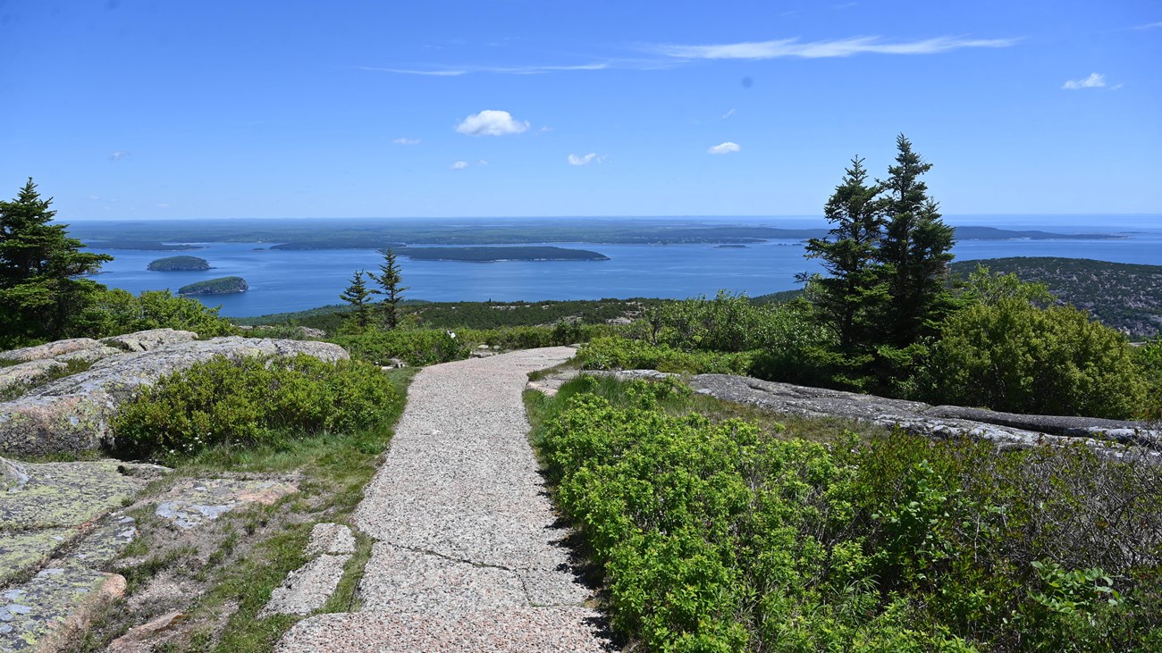
A paved path crosses granite on Cadillac Mountain above Frenchman Bay and wooded islands.
Cadillac Summit Loop · archive viewNPS Photo by Robyn Smyth

Conditions

NPS alerts last checked

Alert list last changed

Check before you go

When to see fall colors

Mid-October is the usual planning target. NPS and Maine Forest Service guidance describe a seasonal pattern, not a guaranteed peak day. Maine's color generally moves north to south. The state lists the second week for Downeast and a broader mid-to-late October window along the coast. It does not give each Acadia trail its own peak date.

September

Earlier inland

Northern Maine usually reaches peak before the coast.

November

Beyond the usual window

Plan around scenery and the operating calendar, rather than peak leaves.

See fall colors by car

Park Loop Road connects woods, lakes and coast on eastern Mount Desert Island. Match the numbered approaches to their photos, then choose where to walk.

Acadia fall-color places Three places on eastern Mount Desert Island, linked by Park Loop Road and its approaches. Numbers match the archive photos below. Cadillac Summit Road is a separate spur. Pins mark walking or shore approaches, not driving arrivals or camera positions. Roads and paths: NPS. Park area: NPS cartographic boundary. State outline: U.S. Census. This map does not show current access or leaf conditions. Kitteredge BrookKitteredge BrookKitteredge BrookKitteredge BrookKitteredge BrookKitteredge BrookKitteredge BrookKitteredge BrookKitteredge BrookKitteredge BrookRichardson BrookRichardson BrookRichardson BrookRichardson BrookRichardson BrookRichardson BrookRichardson BrookRichardson BrookRichardson BrookRichardson BrookRichardson BrookRichardson BrookRichardson BrookRichardson BrookRichardson BrookRichardson BrookRichardson BrookRichardson BrookRichardson BrookRichardson BrookRichardson BrookPark Loop Rd Jordan Pond Rd Paradise Hill Rd Paradise Hill Rd Paradise Hill Rd Park Loop Rd Paradise Hill Rd Jordan Pond North Lot Park Loop Rd Cadillac Summit Rd Park Loop Rd Jordan Pond Rd Paradise Hill Rd Park Loop Rd Cadillac Summit Rd Sieur de Monts Rd Park Loop Rd Paradise Hill Rd Park Loop Rd Park Loop Rd Cadillac Summit Rd Paradise Hill Rd Park Loop Rd Park Loop Rd Sieur de Monts Rd Cadillac Summit Rd Jordan Pond North Lot Park Loop Rd Jesup Path at Sieur de Monts1 Cadillac Summit Loop2 Jordan Pond3Kitteredge BrookN
27-mile Park Loop Road · One-way and two-way sections · Cadillac Summit Road is a separate spur with seasonal vehicle reservations.Three places on eastern Mount Desert Island, linked by Park Loop Road and its approaches. Numbers match the archive photos in the key. Cadillac Summit Road is a separate spur. Pins mark walking or shore approaches, not driving arrivals or camera positions. Roads and paths: NPS. Park area: NPS cartographic boundary. State outline: U.S. Census. This map does not show current access or leaf conditions.
The Jesup Path boardwalk passes a bench and continues through a green white-birch forest.
1Jesup Path at Sieur de MontsBegin near the Wild Gardens entrance. The photo identifies the boardwalk in summer; it does not show fall color or today's conditions.
NPS Photo by Aislinn Gara Grady
A paved path crosses granite on Cadillac Mountain above Frenchman Bay and wooded islands.
2Cadillac Summit LoopThe pin marks a summit-loop trail entrance, reached by the separate summit road. Archive view; check the vehicle-reservation season before driving.
NPS Photo by Robyn Smyth
The Bubbles and autumn woodland rise above Jordan Pond, with sunlit rocks along the shore.
3Jordan PondThe pin marks the boat-launch approach on the south shore, not the distant Bubbles or an exact camera position. Archive autumn photograph.
NPS / Victoria Stauffenberg
  • Selected NPS roads
  • Numbered trail and shore approaches
  • National park area
  • Maine outline
  • Named rivers and streams (USGS NHD)

See fall colors on foot

Choose a mostly level forest walk, a longer pond loop or a short paved summit walk. The maps show nearby trail networks; follow each official description for the walk itself.

A · Jesup Path and Hemlock Path Loop trail-network detail NPS trail-network context, not a complete walking itinerary. The letter marks the mapped start described by NPS. Source accuracy varies; carry the official trail directions. Nearby paths can lead beyond the recommended walk. Cromwell BrookCromwell BrookCromwell BrookCromwell BrookCromwell BrookCromwell BrookCromwell BrookBear BrookBear BrookBear BrookBear BrookBear BrookBear BrookBear BrookSieur de Monts Rd Park Loop Rd Sieur de Monts Rd Great Meadow Loop Sieur de Monts Developed Area Jesup Path Great Meadow Loop Great Meadow Loop Great Meadow Loop Sieur de Monts Developed Area Great Meadow Loop Sieur de Monts Developed Area Hemlock Path Jesup Path Sieur de Monts Developed Area Hemlock Path Sieur de Monts Developed Area Sieur de Monts Developed Area Great Meadow Loop Hemlock Path Jesup Path Jesup Path Great Meadow Loop Sieur de Monts Developed Area Hemlock Path Great Meadow Loop Great Meadow Loop Hemlock Path Great Meadow Loop Sieur de Monts Developed Area Sieur de Monts Developed Area Great Meadow Loop Great Meadow Loop Great Meadow Loop Jesup Path Sieur de Monts Developed Area Sieur de Monts Developed Area Great Meadow Loop Jesup Path and Hemlock Path Loop trail startACromwell BrookBear BrookN
NPS trail-network context, not a complete walking itinerary. The letter marks the mapped start described by NPS. Source accuracy varies; carry the official trail directions. Nearby paths can lead beyond the recommended walk. Trail data: NPS.

AJesup Path and Hemlock Path Loop

1.5-mile round trip · Sieur de Monts, near the Wild Gardens entrance

Birch and hemlock forest, boardwalk and Great Meadow views. The full figure-eight crosses Park Loop Road twice without crosswalks.

Dogs on a leash no longer than 6 feet. Mostly level. The 3-foot-wide boardwalk may not fit some wheelchairs or scooters; boards can be slippery when wet.

  • A · mapped trail network
  • A · trail start
  • Nearby NPS roads
  • National park area
  • Named rivers and streams (USGS NHD)
B · Jordan Pond Path trail-network detail NPS trail-network context, not a complete walking itinerary. The letter marks the mapped start described by NPS. Source accuracy varies; carry the official trail directions. Nearby paths can lead beyond the recommended walk. Hadlock BrookHadlock BrookHadlock BrookHadlock BrookHadlock BrookHunters BrookHunters BrookHunters BrookJordan Pond North Lot Park Loop Rd Park Loop Rd Jordan Pond North Lot Jordan Pond Path Jordan Pond Path Jordan Pond Path Jordan Pond Path Jordan Pond Path Jordan Pond Path Jordan Pond Path Jordan Pond Path trail startBHadlock BrookHunters BrookN
NPS trail-network context, not a complete walking itinerary. The letter marks the mapped start described by NPS. Source accuracy varies; carry the official trail directions. Nearby paths can lead beyond the recommended walk. Trail data: NPS.

BJordan Pond Path

3.3-mile loop · Jordan Pond boat launch, via the North Lot

Walk the east shore first if you may turn back. The western half has boulders, uneven footing and narrow raised planks. This is the longer outing here.

Dogs on a leash no longer than 6 feet. NPS says the full path is not accessible. No wading or swimming; the pond is a drinking-water supply.

  • B · mapped trail network
  • B · trail start
  • Nearby NPS roads
  • National park area
  • Named rivers and streams (USGS NHD)
C · Cadillac Summit Loop trail-network detail NPS trail-network context, not a complete walking itinerary. The letter marks the mapped start described by NPS. Source accuracy varies; carry the official trail directions. Nearby paths can lead beyond the recommended walk. Cadillac Summit Rd Cadillac Summit Rd Cadillac Summit Developed Area Cadillac Summit Developed Area Cadillac Summit Developed Area Cadillac Summit Loop Cadillac Summit Loop Cadillac Summit Loop Cadillac Summit Developed Area Cadillac Summit Loop trail startCN
NPS trail-network context, not a complete walking itinerary. The letter marks the mapped start described by NPS. Source accuracy varies; carry the official trail directions. Nearby paths can lead beyond the recommended walk. Trail data: NPS.

CCadillac Summit Loop

Short paved summit loop · At the summit parking loop, after the Cadillac drive

Views of Frenchman Bay and its islands. The walk begins at the top of the mountain; it is not a hiking route up from Park Loop Road.

Dogs on a leash no longer than 6 feet. Paved sections have steeper grades. NPS notes steps with nearby ramp options; read its detailed access description. Driving has a separate reservation season.

  • C · mapped trail network
  • C · trail start
  • Nearby NPS roads
  • National park area

Acadia crowds by month

October ranks fifth in the park's five-year monthly averages, at about 70% of the busiest month. Lower totals than summer do not guarantee parking at Jordan Pond or another popular stop. September and November provide context around the usual October color window.

Fall months highlightedFall planning context: September through November
LowestLowModerateHighPeakAverage month: 332,670

Acadia fall colors questions

Quick answers for timing your trip and driving the ridge.

When do the leaves change in Acadia?

NPS says the peak generally comes in mid-October. Maine Forest Service lists the second week of October as the typical Downeast peak and gives coastal Maine a broader mid-to-late October window. These regional patterns cannot promise a date for one trail. Check the state foliage report before travel.

Is mid-October too late for Acadia fall foliage?

Mid-October falls within the usual window in NPS guidance. Coastal color can extend later in October, but weather and the year matter. November is beyond the usual peak window; keep a plan for the coast and other scenery if the leaves are past their best.

Is Acadia crowded during fall foliage?

October is the fifth-busiest month in the five-year NPS averages, at about 70% of the busiest month. Those park-wide counts do not measure foliage attendance, queues or available parking. NPS warns that Jordan Pond afternoons can be congested and recommends another time if the lots are full.

Is Park Loop Road normally open in October?

October is within the normal paved-road season. NPS lists April 15 to December 1, with spring opening dependent on weather. Read current conditions and operating calendars before travel. The 27-mile route includes one-way sections, so study the road layout before choosing stops.

Where should I go for fall colors in Acadia?

NPS includes Jesup Path and Hemlock Path Loop, Jordan Pond Path and Park Loop Road in its fall-color suggestions. The 45 miles of motor-free carriage roads offer another way through the woods on foot or by bicycle. Cadillac Summit Loop adds a broad view after a separate drive; check its reservation season.

Do I need a reservation to drive Cadillac in fall?

During the published reservation season, driving Cadillac Summit Road requires a vehicle reservation in addition to the park entrance pass. The vehicle reservation costs $6 and is sold online in advance. NPS does not require that vehicle reservation for entry on foot or by bicycle. Check the official page for the dates that apply to your trip.

What weather should I plan for during fall foliage?

NPS describes fall weather as variable, with a broad seasonal range of 30°F (-1°C) to 70°F (21°C). That is not an October daily forecast. Bring layers and check the forecast for your outing, especially for a summit visit.

How we built this page.

An independent guide using official data. Not affiliated with or endorsed by the National Park Service.

Fall timing
A typical season, not a forecast. Official park guidance explains the seasonal window and local variation. The map photographs show their subjects, not today’s leaf conditions.
Crowd context
2021–2025 monthly averages. NPS recreation visits count park visits, not unique visitors, foliage viewers, parking spaces or weekend traffic.
Trip planning
Official road and trail guidance. Check current conditions and operating calendars before travel. Monthly comparisons include all of September even when the fall window starts late in the month.